When you export geometry from Civil 3D to HEC-RAS using ExportHECRAS, of course you wonder exactly what reach lengths Civil 3D is exporting, since your friction losses are proportional to those lengths, Well. Wonder no more. As of Civil 3D 2016, the reach lengths are exported like this:
 |
| Curvy stream, straight banks, and reach length circles |
In the screen shot above I have exported the geometry shown with a curvy thalweg centerline and straight banks using the ExportHECRAS command. Then I have drawn circles showing the exported lengths. As you can see, the channel reach length (oversized circles) is the length along the thalweg centerline from one section to the next. The right and left overbank reach lengths (circles at banks) are the lengths of the banks from one section to the next. If you are thinking that isn't exactly what you wanted for hydraulic modeling (we would probably prefer the centroid of each overbank area), I agree with you. But at least we know what we are getting. And we can choose what to do about it.
Don't forget that as of Civil 3D 2016, you are expected to export with your alignment running from the upstream end (or Civil 3D is completely confused on the matter, and you have to renumber your sections (running from downstream) and move your lengths (because Civil 3D puts them below instead of above the reaches). See my post on
Simplest method to export geometry from Civil 3D and import to HEC-RAS.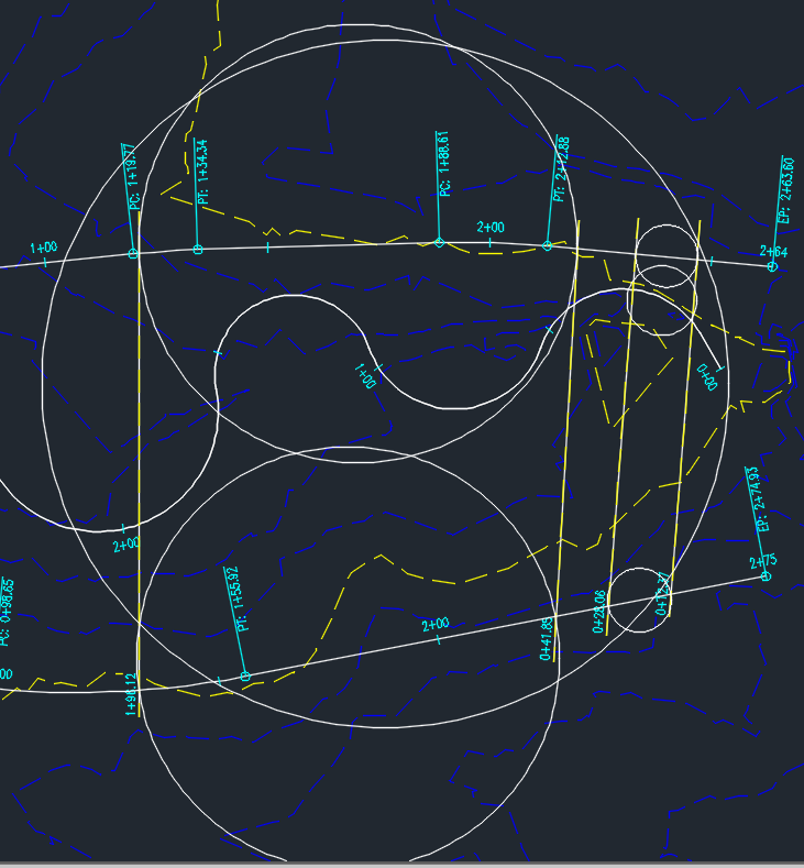
7 comments:
I don't get it. Could you please draw a coloured polyline to indicate the exact calculated length for each one??? This circle - thing is confusing me... Thank you so much.. I'm trying so many days to figure out how can I model my river through Autocad Civil 3D and your bloq is very helpfull!
I'm sorry the circles aren't helpful to you. They aren't very important anyway. The bottom line is that the overbank reach lengths Civil 3D exports for HEC-RAS are the lengths of the left and right banks between stations.
Hi Tom, in your last article you say don't forget to renumber your cross sections and move your lengths. OK, I tried it in the reverse order of import to HEC-RAS but without a success because the program doesn't allow it. Where and how I can do it? Before exporting it in the HEC-RAS or in a SDF file? If it isn't simple could you write an article about it? It would be great. Thanks.
I am adding a link in the appropriate place in this post. Let me know if that doesn't answer your question.
My comment was perhaps a little confusing. I understand all about the export from Civil3D to Hec-RAS, that is clear. What I need is to return results from HEC-RAS to Civil3D but not as a SHP file. Anyway, I can’t make a DEM because my coordinate system is not supported. I want to use a water surface calculated by HEC-RAS as Civil 3D profile (not the profile of HEC-RAS) using a SDF file (in HEC-RAS: File – Export GIS Data -- *.sdf and in Civil3D : importhecras). But It doesn’t work due to the change of cross section's stationing when importing geometry data to HEC-RAS. After import the results, there is an alignment but no profile in Civil3D. Is there a solution to return section’s stationing for the correct import to Civil3D? I hope you understand what I mean and excuse my English.
Wow! Autodesk needs to fix their export and import commands! Apparently they do know about this.
You are way beyond what I know in importing using sdf files. Sorry I don't know the answer to your question.
OK, but even so, thank you for your time.
Post a Comment